 (Click on map for more)
If you are a radio licensee living near the Canadian border, you're probably aware that your activities are restricted north of "Line A". Commercial and Business stations need to coordinate frequency assignments with Canadian frequency coordinators. Amateur stations may not transmit in the 420-430 MHz subband of the 70cm Amateur band. GMRS stations may not use the "650" and "700" channels, either simplex or duplex. I live in Seattle, and I'm told that I'm north of "Line A". But naturally I have to check for myself.
The mysterious Line A is a line drawn in the sand in 1962 by a treaty between the United States and Canada. There are also lines B, C and D.
Line A roughly parallels the border between the Lower 48 States and Canada, about one degree south of the border. Line B is the Canadian counterpart, running about one degree north of the border. Lines C and D bracket the Alaska/Canada border, about 3 degrees either side.
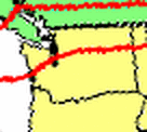
Anyway, up until now, I've had two resources to tell me whether I'm north of Line A. The first is this little cheesy map I've swiped from FCC's website:
It looks to be more of a 20-mile wide defoliation zone than anything else. I can see that maybe Seattle is north of the line. Is Tacoma? How far do I need to drive to satisy that unbearable urge to transmit on 421 MHz? Obviously a better definition is needed. The Amateur Radio Service rules has this to say:
Line A - Begins at Aberdeen, Wash., running by great circle arc to the intersection of 48 degrees N., 120 degrees W., thence along parallel 48 degrees N., to the intersection of 95 degrees W.... [47 CFR 97.3(a)(29), verbatim from original treaty]
I've been to Aberdeen, and it's a little larger than a point on a map. This text doesn't give a latitude and longitude for "Aberdeen, Wash.", but on a small scale map I can draw a line and it's apparent I'm north of Line A, at least a little bit. The line cuts through a densely-populated swath of the Seattle/King County metropolitan area, though.
But what if I need to go to Aberdeen ever again? Is Aberdeen north or south of Line A? Does it go through City Hall or something? Is there a legal definition of "Aberdeen, Wash." that I can guide by?
The answer is yes. Someone in the federal government had the same question I did one day and did some research. He came up with three sets of coordinates for Aberdeen and scratched his head, and bounced the problem "Upstairs". The "Treaty Branch" (I'm not certain whose treaty branch that is, but it doesn't matter) issued a memorandum giving the official party line. According to this memo, "Aberdeen, Wash." is at 46-58-00 N / 123-50-00 W.
So far so good. The Treaty Branch also figured out that there's quite a bit of land to the west of Aberdeen. Where does the line go from there? Straight west? Or in the same direction it came in on?
Turns out you keep going in the same direction. The National Telecommunications and Information Administration took it upon themselves to extend that line far out into the ocean, at least as far as the westernomst point in the Lower 48. They extend Line A to 46-37-00 N / 125-00-00 W.
I penciled this line onto some topo maps, and came up with some guides to tell me whether I'm north or south of the line. (I also told my GPS unit, and now I can see the line on its internal map. It tells me that I live 15.65 km away from the line. Less than 10 miles. Or less than half the width of that defoliation zone they drew for me on that silly map.
So here's the rough guide to what's south of Line A in Washington State.
| Westport: | south of town limits |
| Aberdeen: | Generally south side of Chehalis River |
| US 101: | Insels Road, south of Shelton |
| SR 16: | Interchage at Wollochet Road |
| SR 99: | SR-516 Kent-Des Moines Rd |
| I 5: | Exit 149 (SR-516 Kent-Des Moines Rd) |
| SR 167: | S 212 St exit |
| SR 169: | Jones Rd/196 Ave SE intersection |
| I 90: | Anywhere East of SR-18 interchange (Exit 25) |
| US 2: | East of Merritt to Spokane, then north to Eloika Rd, near Milan |
| (Following are points at Latitude 48 N) | |
| US 97: | South of Starr, near Chelan/Okanagan county line |
| SR 155: | South of Elmer City |
| SR 21: | If you don't have a map, stay south of Lake Roosevelt |
| SR 25: | Ditto |
| SR 231: | South of Reservation Road |
| US 395: | South of Clayton |
| US 2: | South of Eloika Road, near Milan |